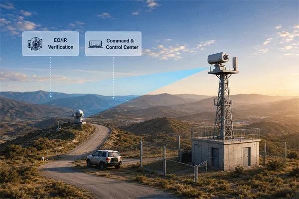
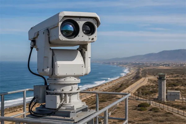
Ports, coastal facilities, offshore terminals and strategic waterways need earlier warning than a camera-only system can normally provide. A Yüzey Gözetleme Radarı can search a wide area, initiate tracks and cue electro-optical sensors, but detecting a small boat close to the sea surface is not a simple “maximum range” problem.
The radar must separate a weak, fluctuating target return from echoes produced by waves, rain, shoreline structures, anchored vessels and moving port machinery. The practical result depends on the complete surveillance chain: radar waveform and processing, installation geometry, target characteristics, track logic, sensor fusion and the way performance is tested.
This guide explains the engineering questions that should be answered before a port or coastal operator accepts a quoted detection range.
How Surface Surveillance Radar Detects Small Boats in Sea Clutter
1. Why Small Boats Are Difficult Radar Targets
A small surface target can be difficult to detect even when it is geographically close to the radar. Several effects occur at the same time:
- Low and unstable radar cross section. Inflatable craft, fiberglass hulls, wooden boats and partially submerged objects may return much less energy than large steel vessels.
- Wave masking. A low hull can be obscured by wave crests, particularly at long range and low grazing angles.
- Target fluctuation. The apparent radar return changes with aspect angle, pitching, rolling, engine vibration and intermittent exposure above the waves.
- Small Doppler separation. A drifting or slow-moving craft may have radial velocity close to the motion of the surrounding sea surface.
- Clutter competition. Sea spikes, rain cells, shoreline reflections and large moving vessels can produce stronger returns than the target of interest.
For this reason, a specification such as “radar range: 50 km” is incomplete. It may describe the instrumented display range, the detection of a large cooperative vessel, or a laboratory configuration. A useful requirement must identify the target, probability of detection, permitted false-alarm rate, track continuity and environmental conditions.
2. Sea Clutter Is Dynamic, Non-Uniform and Location-Dependent
Sea clutter is the radar energy backscattered by the moving sea surface. It is not a fixed background that can be removed once and forgotten. Its statistical behavior changes over time and across range cells as wind, wave direction, rain, tide and viewing geometry change.
The most important site variables include:
- Sea state, significant wave height and wave direction.
- Wind speed and whether the radar is looking upwind, downwind or across the wind.
- Grazing angle, which is influenced by radar height, target distance and local topography.
- Rain intensity, spray, fog and atmospheric ducting.
- Shoreline geometry, breakwaters, cranes, container stacks and fixed infrastructure.
- Large-vessel traffic, wakes and rotating machinery within the surveillance sector.
A radar tuned at one harbor can behave differently at another harbor. Adaptive processing is therefore more valuable than a single fixed threshold.
3. Detection, Track Initiation and Stable Tracking Are Different
A buyer should distinguish at least four stages:
| Stage |
Operational meaning |
Typical acceptance question |
| Plot detection |
A radar cell exceeds a detection threshold. |
Was a target-like return produced at the required range? |
| Track initiation |
Multiple plots are associated and promoted to a track. |
How many scans are required before an alarm-quality track appears? |
| Stable tracking |
The system maintains identity, position, speed and heading. |
What is the track continuity during maneuvers, wave masking and vessel crossings? |
| Classification / verification |
The system assigns a class or cues EO/IR for confirmation. |
Can the operator distinguish a small craft from clutter, buoys or birds? |
A system can occasionally produce a plot at long range yet fail to form a stable operational track. Procurement documents should therefore specify track-level performance rather than relying only on a first-detection claim.
4. Radar Parameters That Affect Maritime Performance
Operating frequency and resolution
Higher-frequency radar can provide narrow beams and fine resolution from a relatively compact antenna, which is useful for separating targets in a congested port. However, frequency alone does not determine performance. Antenna aperture, transmitted waveform, bandwidth, coherent processing, polarization and clutter algorithms must be evaluated as a system.
Range and angular resolution
Range resolution helps separate two objects located at similar bearings but different distances. Angular resolution helps separate vessels close together in azimuth and reduces the amount of shoreline or sea clutter inside one resolution cell. Poor resolution can merge a small craft with a breakwater, buoy or large vessel.
Doppler processing and minimum detectable velocity
Moving-target processing can separate a vessel from static infrastructure, but very slow targets are difficult when their radial velocity overlaps with sea motion. Buyers should request the minimum and maximum measurable radial velocity, the behavior of the zero-velocity filter and the consequences for drifting targets.
Adaptive thresholding and CFAR
Constant false-alarm-rate processing estimates the local clutter background and adjusts the detection threshold. In a non-homogeneous harbor, guard cells, reference-window selection and clutter-map behavior matter. A threshold that is too low produces nuisance alarms; one that is too high suppresses weak boats.
Track-before-detect and multi-scan integration
Weak targets can sometimes be recovered by integrating evidence over time before declaring a conventional detection. The trade-off is latency: longer integration may improve sensitivity but delay the warning. The acceptable balance depends on the protected zone and target speed.
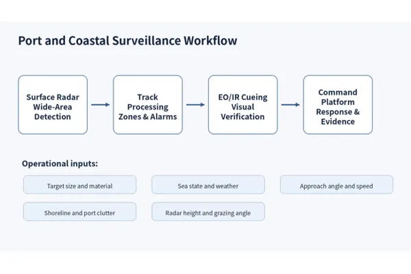
A practical port surveillance chain combines radar detection, track processing, EO/IR verification and command response.
5. Installation Geometry Can Change the Result
The same radar can produce very different coverage when installed at different heights or positions. A site survey should include:
- Radar horizon and line-of-sight analysis.
- Shadow zones created by terrain, buildings, cranes and large ships.
- Near-field blind zones and minimum range.
- Grazing-angle changes across the protected water area.
- Multipath from the sea surface and nearby metallic structures.
- Sector overlap where two radar units are used.
- Cable, network, power, lightning and corrosion constraints.
Installing the radar as high as possible is not automatically optimal. Greater height can improve the horizon, but it also changes the grazing angle, clutter footprint and mechanical exposure to wind. Coverage should be modeled for the actual target height and route.
6. Why Radar Should Cue EO/IR Instead of Working Alone
Radar is efficient at wide-area search and coordinate generation. EO/IR is better suited to visual confirmation, evidence capture and operator interpretation. The combined workflow is:
- Radar detects a target and initiates a track.
- The command platform predicts the target position and converts it into pan, tilt and zoom commands.
- The EO/IR unit slews to the predicted line of sight.
- Visible, thermal or laser-assisted imaging supports classification.
- Rules based on exclusion zones, direction and speed determine the response.
AIS and vessel-management data can add context for cooperative vessels, but AIS should not be treated as a substitute for independent sensing. Small craft may have no transponder, may switch it off, or may transmit inaccurate information.
7. A Better Port Acceptance Test
A credible site acceptance test should represent the operational problem. Testing one large metal boat on a calm day proves very little about small-craft surveillance.
| Test variable |
Recommended test design |
| Target set |
Include a representative rigid inflatable boat, fiberglass craft, workboat and large vessel. |
| Target dimensions |
Record length, beam, freeboard, material and radar reflector status. |
| Aspect |
Run inbound, outbound and crossing tracks; include bow, stern and beam aspects. |
| Hız |
Test drift/very slow, normal transit and high-speed approach. |
| Environment |
Record wind, wave height, precipitation, visibility and tide. |
| Range points |
Define required first plot, confirmed track and stable-track ranges. |
| Track quality |
Measure continuity, position error, speed/heading stability and track swaps. |
| False alarms |
Count nuisance tracks per unit area and time under representative traffic. |
| EO/IR cueing |
Measure slew time, pointing error and confirmation success. |
| Reporting |
Preserve radar logs, weather data, target GPS and synchronized video. |
The acceptance threshold should be agreed before the trial. For example, the contract may require a defined probability of stable track within a protected approach corridor while keeping nuisance alarms below an agreed rate. The exact numbers depend on risk, response time and site geometry.
8. Questions to Ask a Surface-Radar Supplier
- Is the quoted range instrumented range, first plot range or stable-track range?
- What target size, material, aspect and speed were used?
- What sea state, rain rate and radar height applied during the test?
- What detection probability and false-alarm criterion were used?
- How does the radar handle drifting or low-radial-velocity craft?
- What is the update rate and how many targets can be tracked in a congested harbor?
- Can the system create shoreline masks, exclusion zones and speed/direction rules?
- How are tracks exported to EO/IR, VMS, PSIM or command-and-control software?
- What raw data and logs are available for factory and site acceptance testing?
- What corrosion, salt-fog, lightning and maintenance provisions are included?
9. Midradar System Architecture for Coastal Projects
Midradar’s surface-surveillance portfolio includes compact and long-range radar configurations for ground and coastal monitoring. Models such as the MR-RDG20K and MR-RDG50K are designed to provide target coordinates for wide-area surveillance and can be integrated with long-range EO/IR cameras and radar-vision fusion software.
The correct configuration should be selected from the protected water geometry, smallest representative target, required warning time, traffic density, environmental conditions and integration requirements—not from maximum range alone.
SSS
Can a coastal radar detect an inflatable boat?
It may be possible, but the answer depends on craft size, material, freeboard, aspect, speed, sea state, radar geometry and the required probability of track. A field test with a representative craft is the most reliable validation.
Does X-band automatically provide better small-boat detection?
X-band is widely used for fine-resolution maritime sensing, but band alone is not sufficient. Antenna aperture, waveform, coherent processing, clutter suppression and installation geometry determine operational performance.
Is AIS enough for port surveillance?
No. AIS is valuable for cooperative traffic identification but does not independently detect non-cooperative, unregistered or incorrectly reporting targets.
What is the difference between detection range and tracking range?
Detection range can refer to an isolated plot. Tracking range normally requires repeated detections and a stable track with position, speed and heading. The latter is more meaningful for security operations.
How many radar units does a port need?
The number depends on coastline shape, obstructions, required redundancy, sector width, radar horizon and blind-zone tolerance. A coverage study should be completed before equipment quantity is fixed.



 13:45
13:45