Project Snapshot
| Ürün |
Details |
| Endüstri |
Civil Aviation / Airport Operations |
| Region |
Northeast Asia |
| Environment |
Coastal hub airport in a high bird-activity region, located near protected wetland and estuarine habitats along a major migratory route |
| Core Challenge |
No real-time bird detection at night or in adverse weather; no early warning range; no flock quantification data |
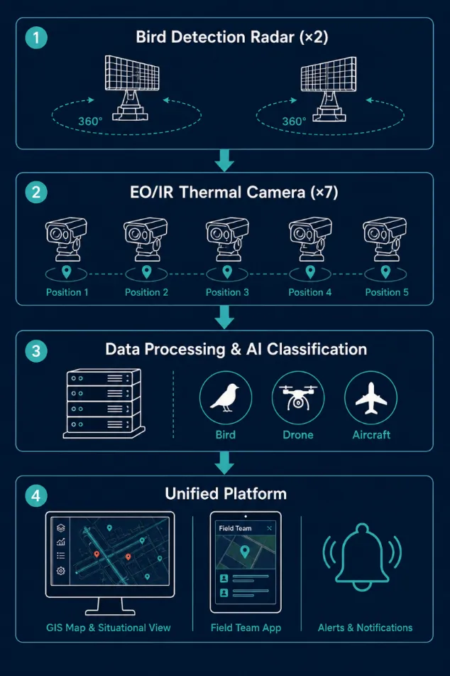
| Radar Deployed |
2 × MR-RDT10K Low-Altitude Surveillance Radar |
| Camera Deployed |
7 × MR-HTVC12035-2132 Long-Range PTZ Thermal Camera |
| Platform |
Unified bird risk management platform — GIS display, risk zoning, automated alerts, playback, statistics, tablet field interface |
| Project Duration |
24 months (12 months construction + 12 months seasonal optimization) |
| Key Outcome |
24/7 all-weather bird monitoring across all runway zones with automated risk grading and real-time field team dispatch |

Background
Bird strikes represent one of the most consistently documented aviation safety risks, recognized as a priority concern by ICAO, FAA, and EASA. This airport is a major international hub located in a coastal region of Northeast Asia with high year-round bird activity. Protected wetland and estuarine habitats in the surrounding area lie within a few kilometers of the runway system, creating sustained exposure that intensifies during seasonal migration when large-scale bird movements frequently coincide with peak flight operations.
The airport’s existing bird management relied on ground patrols, tower observation, and reactive response once birds were already spotted. Four limitations made this approach increasingly inadequate as air traffic volume grew:
· No night or low-visibility coverage: Visual monitoring cannot track bird movement in darkness, fog, or rain — conditions that continue through normal flight operations
· Insufficient warning range: By the time birds were visually detected near runways, lead time for dispersal was frequently too short before an aircraft reached approach or departure roll
· No flock quantification: Operators had no systematic way to measure flock density, altitude distribution, or movement trajectory, making risk assessment subjective and shift-dependent
· No data for habitat intervention: Without continuous observation records, the airport lacked the evidence base to target bird attractant reduction work around the perimeter
Bird strike incidents were trending upward, contributing to aircraft damage, unscheduled maintenance, and operational delays. A transition to a radar-based, sensor-fused detection system was determined necessary to meet operational requirements and civil aviation safety obligations aligned with ICAO Doc 9137.
Sistemin Çalışma Prensibi
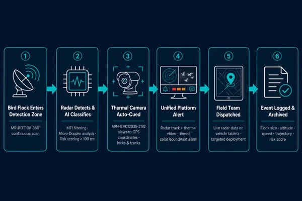
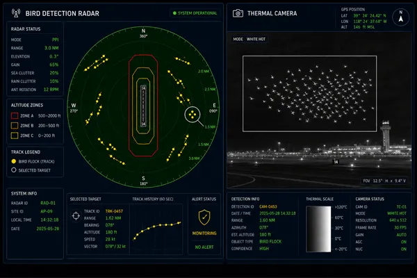
The deployed system follows a Detect → Track & Classify → Alert & Respond workflow. Two MR-RDT10K radars provide continuous 360° airspace coverage. When a bird target is detected and classified, the platform automatically cues the nearest MR-HTVC12035-2132 thermal camera for visual verification, triggers tiered alerts in the control room, and simultaneously pushes live track data to field team tablets — designed for a sub-100 ms end-to-end response from detection to alert dispatch.
Çözüm
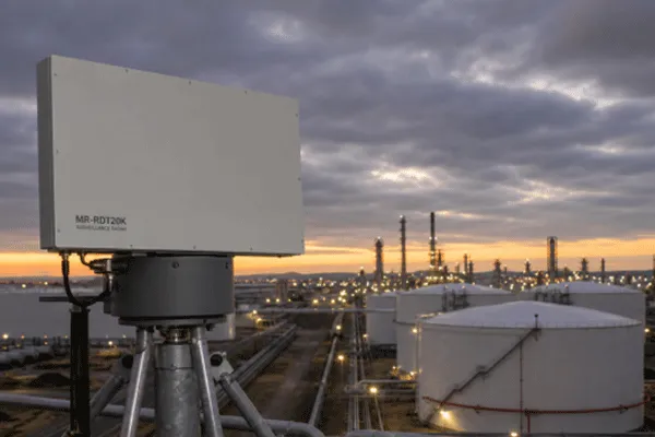
MR-RDT10K — Area-Wide All-Weather Radar Algılama
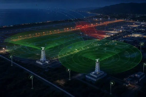
Two MR-RDT10K units are installed on 10-metre frangible support structures positioned for overlapping coverage across the full runway environment and surrounding low-altitude airspace. Using mechanical azimuth scanning and elevation Digital Beamforming (DBF), the MR-RDT10K is designed to deliver continuous 360° surveillance regardless of lighting or weather.
| Parametre |
Şartname |
| Azimut Kapsamı |
360° continuous |
| Yükseklik Kapsamı |
−5° to +60° |
| Max Detection Altitude |
3,000 m |
| Detection Range (RCS 1 m² / bird flock class) |
3.5 km – 20 km |
| Detection Range (RCS 0.01 m² / small target) |
1.5 km – 10 km |
| Target Velocity Range |
1 m/s – 150 m/s |
| Range Accuracy (RMS) |
≤ 5 m |
| Velocity Accuracy (RMS) |
≤ 0.5 m/s |
| Angular Accuracy (AZ/EL, RMS) |
0.3° – 0.4° |
| Simultaneous Track Capacity |
≥ 200 tracks |
| End-to-End Response (design target) |
< 100 ms |
| Çalışma Sıcaklığı |
−40 °C to +55 °C |
| Giriş Koruma |
IP66 |
MTI/GMTI algorithms suppress ground and sea clutter, enabling reliable detection of slow-moving, low-RCS targets including individual large birds and small flocks that would be masked in conventional surveillance radar returns. Midradar’s AI classification engine provides multi-class target discrimination across bird flocks, individual birds, UAVs, and aircraft in real time. A Micro-Doppler feature recognition layer further distinguishes rotor-driven UAV echoes from biological wing-flapping bird echoes at signal processing level, significantly reducing nuisance alarms from non-bird aerial targets.
MR-HTVC12035-2132 — Long-Range Thermal PTZ Verification
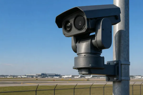
Seven MR-HTVC12035-2132 PTZ thermal camera units are deployed at five installation points: three ground-level pole positions, three building rooftop positions, and one elevated tower location providing extended coverage over the most active migratory approach corridors.
| Parametre |
Şartname |
| Detection Range (vehicle / human) |
21 km / 9 km |
| Termal Sensör |
VOx uncooled, up to 1280×1024 resolution |
| Spektral Tepki |
7.5 μm – 14 μm |
| NETD |
45 mK |
| Termal Lens |
25 mm – 325 mm, 13× continuous zoom, autofocus |
| Görünür Kamera |
2.1 MP, 1/1.8″ CMOS |
| Görünür Mercek |
4.3 mm – 141 mm, 30× optical zoom |
| Minimum Aydınlatma |
0.0002 lux |
| PTZ Pan |
0°–360° sürekli |
| Çalışma Sıcaklığı |
−35 °C to +60 °C |
| Koruma Seviyesi |
IP66, triple-proof coating |
The thermal channel provides reliable target imaging in complete darkness, rain, mist, and direct solar backlighting — conditions that degrade visible-light cameras precisely when migrating flocks are most active. With a 21 km vehicle detection range and 9 km human-scale recognition range, thermal verification remains effective well before birds enter critical runway proximity. Camera cueing is fully automated via Midradar’s optoelectronic linkage interface — the nearest unit slews to the target’s GPS coordinates, locks on, and begins tracking with no manual control required.
Unified Bird Risk Management Platform
The integrated platform delivers the full operational capability set for airport bird strike prevention:
· Unified situational display: Radar tracks, thermal and visible video, aircraft movement (MLAT integration), and risk zone overlays on a single GIS-based operator interface
· Risk zone management: Runway segments and approach corridors divided into horizontal and altitude-based tiers, each with configurable independent alert thresholds
· Target data logging: Every tracked event recorded with GPS coordinates, altitude, range, speed, heading, flock size estimate, and classification label
· Bird risk scoring: Real-time risk index computation integrating flock size, speed, altitude, trajectory, and proximity to active runway zones
· Trajectory playback and statistics: Full historical track data queryable by zone, time, and target type; automated reporting for regulatory documentation and habitat management
· Tablet field interface: Live radar track display on vehicle-mounted tablets for bird control patrol teams — enabling targeted dispersal without voice relay from the control center
· System redundancy: Redundant processing servers and resilient network architecture designed to eliminate single points of failure
· Integration-ready: Open interfaces for ATIS, MLAT, UAM platforms, and anti-drone effector systems
Sistem Mimarisi
Deployment Highlights
Frangible structure design and compliance: Both MR-RDT10K support structures required structural load calculations, collision analysis, and ground stability verification before installation, coordinated with the airport authority and civil aviation regulatory body in accordance with aviation safety regulations for frangible construction.
Nighttime-only installation: All integration with the airport’s live communications infrastructure was performed during nighttime maintenance windows across a multi-month schedule, requiring coordination between air traffic control, facilities management, and the installation team to protect flight operations continuity.
RF coordination in a multi-radar environment: With approach radar, surface movement radar, and weather radar already operating on site, frequency allocation for the MR-RDT10K required a full radio wave simulation and RF environment survey during Detailed Design, followed by formal national frequency licensing.
12-month seasonal optimization: Following construction handover, a dedicated optimization phase calibrated MR-RDT10K sensitivity thresholds, adjusted risk zone alert parameters, and refined AI classification performance using one complete seasonal cycle of actual observed bird activity — accounting for local species composition, migration timing, flock size variation, and the operational schedule of the airport.
Outcomes
After commissioning and optimization, the airport transitioned from reactive visual observation to proactive, data-driven bird risk management across all operational hours and weather conditions. The following operational improvements were achieved and confirmed during the optimization phase:
· Continuous all-weather runway coverage: The radar layer provides detection capability during nighttime and low-visibility conditions that were previously unmonitored, covering all operational hours without additional staffing
· Extended early warning range: Bird activity is now tracked at range before flocks approach critical runway proximity, giving field teams lead time to deploy dispersal measures prior to aircraft movement — a fundamental shift from the previous reactive model
· Consistent, graded alert workflow: Automated tiered alerts replace unclassified visual sightings, enabling standardized response decisions across all shifts and weather conditions
· Structured per-incident documentation: Every tracked event is logged with flock size estimate, altitude, speed, trajectory, and risk score — providing the objective incident record that manual observation could not produce
· Targeted field team deployment: Bird control patrol vehicles are directed by live radar data to active threat locations rather than operating fixed patrol routes
· Seasonal bird activity database: The 12-month optimization period produced a continuous spatial and temporal bird activity record, giving the airport authority a data foundation for habitat management decisions around the airport perimeter
Note: Quantitative metrics including strike rate reduction and system-level false alarm rates are subject to ongoing airport authority review and confidentiality requirements. Operational performance figures will be updated upon authorization.
Frequently Asked Questions
Why is radar required — can thermal cameras handle airport bird detection alone?
Thermal cameras are highly effective for visual verification and close-range identification, but cannot provide wide-area, volumetric, all-weather detection at airport scale. The MR-RDT10K is designed to scan a multi-kilometre radius continuously in complete darkness or zero-visibility conditions — environments where any camera-based system faces fundamental physical constraints. Flock density quantification, altitude distribution mapping, and simultaneous tracking of hundreds of targets across an entire airport airspace volume are radar functions. The combination of radar detection and thermal camera verification is the accepted standard for professional airport bird strike prevention systems.
How does the MR-RDT10K distinguish birds from aircraft and drones simultaneously?
The MR-RDT10K AI classification engine provides multi-class target discrimination across bird flocks, individual birds, UAVs, and aircraft from a single sensor. Micro-Doppler feature recognition further distinguishes rotor-driven UAV echoes from biological wing-flapping bird echoes at signal processing level. Aircraft movement data from existing MLAT infrastructure can be overlaid on the display for combined air picture awareness and toggled off by operator selection. This layered approach is designed to minimize false alerts from non-bird aerial targets during normal airport operations.
How are alert thresholds calibrated to avoid nuisance alarms?
The 12-month optimization phase calibrates all alert parameters using one full seasonal cycle of actual bird activity data at the specific airport — local species composition, typical flock sizes, migration timing, and active runway operational schedules. This produces a site-specific alarm configuration rather than generic factory defaults, allowing the system to balance detection sensitivity against nuisance alarm rate for the particular operational environment.
Can the system connect with existing bird dispersal equipment and future anti-drone platforms?
Yes. Midradar’s standard interfaces support connection with acoustic, laser, and pyrotechnic dispersal devices, allowing existing equipment to be triggered automatically based on radar-detected bird activity. The platform also provides open integration interfaces for ATIS, UAM operational platforms, and anti-drone effector systems — keeping the bird detection investment architecturally compatible with the airport’s broader low-altitude airspace management roadmap.